Today while looking at a chart of abbreviations of Canadian provinces I noticed a province I hadn't heard of before, Nunavut. Of course being American means you can be totally oblivious and ignorant of other countries so it's easy to understand why I missed this new province. Anyway, it peaked my interest and I feel like I should share what I learned.
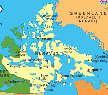
Nunavut was formed in 1999 breaking away from the Northwest Territories as part of a settlement of Inuit land claims for this major Inuit homeland. The territory stretches from Manitoba to Greenland and the North Pole and is comprised mainly of islands in the Artic Ocean and the mouth of Hudson's Bay.
As of 2001 Nunavut's population stood at 29,000 in 26 communities (this is one of the most sparsely populated areas in the world). Nunavut's population is about 85% Inuit and according to the government's website, "...government, business and day-to-day life are shaped by Inuit Qaujimajatuqangit, the traditional knowledge, values and wisdom of Nunavut's founding people." Signs are written in both English and the Inuit language, Inuktitut.

Nunavut flag and logo...
None of Nunavut's 26 communities are connected by road or rail and are only accessible by plane or boat making the territory very expensive to live or visit. The climate is very harsh with most of the country being as far north as Alaska and much of it above the arctic circle. There is an abundance of wildlife including caribou, whales and bears that makes Nunavut popular with hunters and fishermen and nature lovers in general. It's also becoming a popular tourist destination because of the native population's cultural activities.
For more information on Nunavut, visit their page on Yahoo Travel, Nunavut Tourism, and the Government of Nunavut website.
Subscribe to:
Post Comments (Atom)

Hey, it's Brandon!

About Me
I'm a 32 year-old dude who is happily married to his best friend in the whole world and just welcomed a beautiful little girl into our happy family. I love playing softball, basketball and soccer despite my amazing suckiness at all sports. I'm a shining example of what one can accomplish after six years of college without earning a degree.
DWP! Pictures
DWP! Tweets
My Blog List
The Archives
-
▼
2004
(161)
-
▼
November
(26)
- "Next Blog" Roundup
- Music War, Part One
- Huskies Win Great Alaska Shootout
- Taj Mahal at Jazz Alley
- Happy Thanksgiving Suckas!
- The First and Last Post on the Brawl
- Yanni In Spokane
- Huskies Top Seattle Pacific 89-71
- Geography 101: Nunavut, Canada
- Template Changes
- Bush Chokes His Chicken (I Know, It's Really a Tur...
- The Conet Project
- Down With Pants! Scoreboard Campaign
- The Polar Express in 3-D
- Haloscan Commenting
- Huskies Rout Westmont College 92-52
- One More Optimistic Viewpoint
- Marry An American
- Our Halloween Costumes
- Buy Some Crap From Me!
- Barack Obama
- DWP! Concedes PUD to Corwin
- Kerry Concedes - Bush Is Back
- The Election...
- The Three Candidates
- 'Cornhole' Catching on Beyond Midwest
-
▼
November
(26)
0 comments:
Post a Comment